Rister or Sign In to see pricing information


Title:

A New and Accurate Map of Virginia & Maryland Laid Down from Surveys and Regulated by Astronl Observatns

Map Maker:

Emanuel Bowen

A New and Accurate Map of Virginia & Maryland Laid Down from Surveys and Regulated by Astronl Observatns

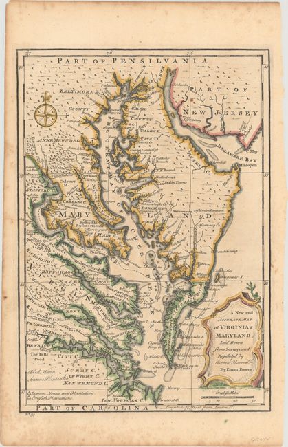
This uncommon map centered of the Chesapeake Bay r... (full text available to subscribers)
Item Detail
 
  MapMaker:  

Emanuel Bowen


  Subject:  Colonial Mid-Atlantic United States  
  Period/Size:  1747 / 12.9" x 9.0"  (32.8 x 22.9 cm)  
  Color:  Colored  
  Condition:  (B+) Nice impression with a few small spots of foxing. (condition help)  
  Source:  A Complete System of Geography  
  References:  McCorkle (18th C. Geography Books) #17, Vol. II [30].  
 
 
Sales Information
 
  Price: 

Please register your email to view records, or sign in with email address to see records


  Offered by:  Old World Auctions  
  Catalog:  Auction No. 157 - Antique Maps, Charts, Atlases & Globes (9290)  
  Lot/Item #:  193  
 
  Date:  05/2016  


Antique Maps - Valuation and Pricing, Descriptions, Resources


Home | Information | Search | Register | Contact Us | Site Map

Americana Exchange, Inc. © 1999 - 2024 Americana Exchange, Inc.. All rights reserved. OldMaps.com, the OldMaps.com logo and
AMPR are service marks or registered service marks of Americana Exchange, Inc..