Title:
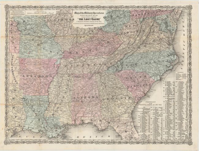
“Map of the Military Operations During the War of 1861-1865 Designed Expressly to Accompany "The Lost Cause" a Standard Southern History of the War”
Map Maker:
G.W. & C.B Colton [& Co.]
This uncommon Civil War era map focuses on the Sou... (full text available to subscribers)
| Item Detail |
| |
| |
MapMaker: |
G.W. & C.B Colton [& Co.]
|
|
| |
| |
Subject: |
Southern United States, Civil War |
|
| |
Period/Size: |
1867 / 18.0" x 24.0" (45.8 x 61.0 cm)
|
|
| |
Color: |
Colored
|
|
| |
Condition: |
(A) A mostly clean and bright example with a bit of toning along two folds and a few tiny fold separations closed on verso with archival tape. Issued folding. (condition help) |
|
| |
Source: |
|
|
| |
References: |
|
|
| |
|
|
| Sales Information |
| |
| |
Price: |
|
|
| |
| |
Offered by: |
Old World Auctions |
|
| |
Catalog: |
Auction No. 157 - Antique Maps, Charts, Atlases & Globes (9290) |
|
| |
Lot/Item #: |
219 |
|
| |
| |
Date: |
05/2016
|
|
| |
| |
|
Antique Maps - Valuation and Pricing, Descriptions, Resources |
|
Home |
Information |
Search |
Register |
Contact Us |
Site Map
Americana Exchange, Inc. © 1999 - 2024 Americana Exchange, Inc.. All rights reserved.
OldMaps.com, the OldMaps.com logo and
AMPR are service marks or registered service marks of Americana Exchange, Inc..
|