Title:
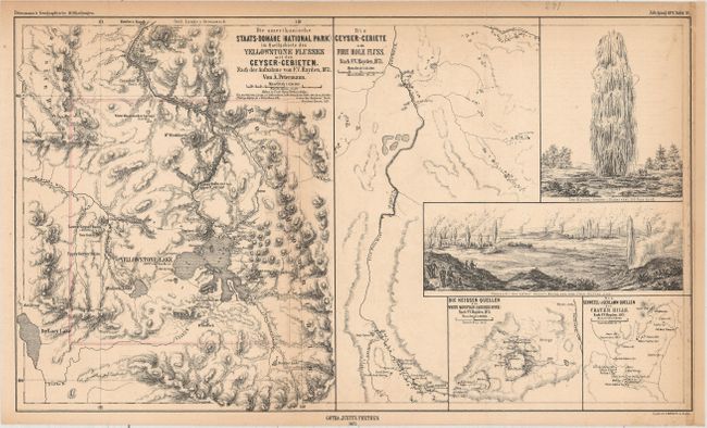
“Die Amerikanische Staats-Domane (National Park) im Quellgediete des Yellowstone Flusses mit den Geyser-Gebieten”
Map Maker:
Augustus Heinrich Petermann
This map was issued in the same year Yellowstone N... (full text available to subscribers)
| Item Detail |
| |
| |
MapMaker: |
Augustus Heinrich Petermann
|
|
| |
| |
Subject: |
Yellowstone National Park, Wyoming |
|
| |
Period/Size: |
1872 / 9.7" x 16.7" (24.7 x 42.5 cm)
|
|
| |
Color: |
Colored
|
|
| |
Condition: |
(B+) Light toning primarily along the top and right side margins. The right side margin has also been extended with old paper to better accommodate framing. Backed with tissue. (condition help) |
|
| |
Source: |
Geographische Mittheilungen |
|
| |
References: |
|
|
| |
|
|
| Sales Information |
| |
| |
Price: |
|
|
| |
| |
Offered by: |
Old World Auctions |
|
| |
Catalog: |
Auction No. 157 - Antique Maps, Charts, Atlases & Globes (9290) |
|
| |
Lot/Item #: |
339 |
|
| |
| |
Date: |
05/2016
|
|
| |
| |
|
Antique Maps - Valuation and Pricing, Descriptions, Resources |
|
Home |
Information |
Search |
Register |
Contact Us |
Site Map
Americana Exchange, Inc. © 1999 - 2024 Americana Exchange, Inc.. All rights reserved.
OldMaps.com, the OldMaps.com logo and
AMPR are service marks or registered service marks of Americana Exchange, Inc..
|