Title:
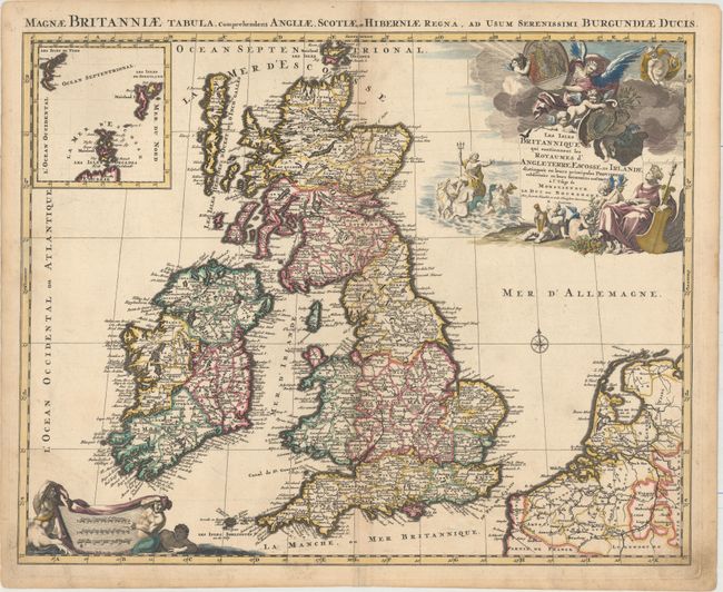
“Les Isles Britanniques qui Contiennent les Royaumes d'Angleterre, Escosse, et Irlande Distingues en Leurs Principales Provinces...”
Map Maker:
Alexis-Hubert Jaillot
This is the first edition of this decorative folio... (full text available to subscribers)
| Item Detail |
| |
| |
MapMaker: |
Alexis-Hubert Jaillot
|
|
| |
| |
Subject: |
Britain |
|
| |
Period/Size: |
1695 / 18.9" x 23.7" (48.0 x 60.2 cm)
|
|
| |
Color: |
Colored
|
|
| |
Condition: |
(B+) A dark impression and original outline color with later coloring in the cartouches. There is very light toning along the centerfold and minor soiling in the blank margins. (condition help) |
|
| |
Source: |
Atlas Royal |
|
| |
References: |
Phillips (A) #5953-15; Shirley (BI to 1750) Jaillot 4. |
|
| |
|
|
| Sales Information |
| |
| |
Price: |
|
|
| |
| |
Offered by: |
Old World Auctions |
|
| |
Catalog: |
Auction No. 157 - Antique Maps, Charts, Atlases & Globes (9290) |
|
| |
Lot/Item #: |
449 |
|
| |
| |
Date: |
05/2016
|
|
| |
| |
|
Antique Maps - Valuation and Pricing, Descriptions, Resources |
|
Home |
Information |
Search |
Register |
Contact Us |
Site Map
Americana Exchange, Inc. © 1999 - 2024 Americana Exchange, Inc.. All rights reserved.
OldMaps.com, the OldMaps.com logo and
AMPR are service marks or registered service marks of Americana Exchange, Inc..
|