Title:
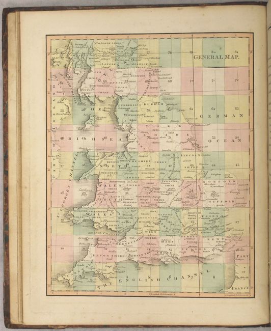
“Cary's New Map of England and Wales, with Part of Scotland. On Which Are Carefully Laid Down All the Direct and Principal Cross Roads, the Course of the Rivers and Navigable Canals...”
Map Maker:
John Cary
This large, incredibly detailed map of Britain is ... (full text available to subscribers)
| Item Detail |
| |
| |
MapMaker: |
John Cary
|
|
| |
| |
Subject: |
Britain |
|
| |
Period/Size: |
1794 / 12.1" x 9.8" (30.8 x 24.9 cm)
|
|
| |
Color: |
Colored
|
|
| |
Condition: |
(B+) The map sheets are overall very good with original outline color and light offsetting. Covers are moderately worn with bumped edges. (condition help) |
|
| |
Source: |
|
|
| |
References: |
|
|
| |
|
|
| Sales Information |
| |
| |
Price: |
|
|
| |
| |
Offered by: |
Old World Auctions |
|
| |
Catalog: |
Auction No. 157 - Antique Maps, Charts, Atlases & Globes (9290) |
|
| |
Lot/Item #: |
452 |
|
| |
| |
Date: |
05/2016
|
|
| |
| |
|
Antique Maps - Valuation and Pricing, Descriptions, Resources |
|
Home |
Information |
Search |
Register |
Contact Us |
Site Map
Americana Exchange, Inc. © 1999 - 2024 Americana Exchange, Inc.. All rights reserved.
OldMaps.com, the OldMaps.com logo and
AMPR are service marks or registered service marks of Americana Exchange, Inc..
|