Title:
“School Atlas to Accompany Woodbridge's Rudiments of Geography”
Map Maker:
William Channing Woodbridge
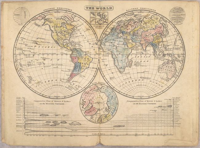
Complete, early school atlas containing the nine d... (full text available to subscribers)
| Item Detail |
| |
| |
MapMaker: |
William Channing Woodbridge
|
|
| |
| |
Subject: |
Atlases |
|
| |
Period/Size: |
1823 / 9.5" x 6.5" (24.2 x 16.6 cm)
|
|
| |
Color: |
Colored
|
|
| |
Condition: |
(B) Maps have overall light to moderate foxing. The map of North America is heavily foxed (C+) and the map of the United States has a 1" centerfold separation at bottom. Covers are in surprisingly very good condition with light wear. (condition help) |
|
| |
Source: |
|
|
| |
References: |
|
|
| |
|
|
| Sales Information |
| |
| |
Price: |
|
|
| |
| |
Offered by: |
Old World Auctions |
|
| |
Catalog: |
Auction No. 157 - Antique Maps, Charts, Atlases & Globes (9290) |
|
| |
Lot/Item #: |
744 |
|
| |
| |
Date: |
05/2016
|
|
| |
| |
|
Antique Maps - Valuation and Pricing, Descriptions, Resources |
|
Home |
Information |
Search |
Register |
Contact Us |
Site Map
Americana Exchange, Inc. © 1999 - 2024 Americana Exchange, Inc.. All rights reserved.
OldMaps.com, the OldMaps.com logo and
AMPR are service marks or registered service marks of Americana Exchange, Inc..
|