Title:
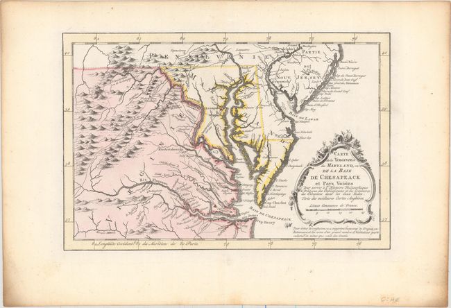
“Carte de la Virginie et du Maryland, ou de la Baie de Chesapeack et Pays Voisins...”
Map Maker:
Jacques Nicolas Bellin
Finely engraved colonial map that covers most of V... (full text available to subscribers)
| Item Detail |
| |
| |
MapMaker: |
Jacques Nicolas Bellin
|
|
| |
| |
Subject: |
Colonial Mid-Atlantic United States |
|
| |
Period/Size: |
1773 / 7.4" x 11.3" (18.8 x 28.7 cm)
|
|
| |
Color: |
Colored
|
|
| |
Condition: |
(A) A fine impression with original color and light toning along the edges of the sheet, well away from image. (condition help) |
|
| |
Source: |
Raynal's Atlas Portatif |
|
| |
References: |
cf. Sellers & Van Ee #1383. |
|
| |
|
|
| Sales Information |
| |
| |
Price: |
|
|
| |
| |
Offered by: |
Old World Auctions |
|
| |
Catalog: |
Auction No. 156 - Antique Maps, Charts, Atlases & Globes (9289) |
|
| |
Lot/Item #: |
194 |
|
| |
| |
Date: |
02/2016
|
|
| |
| |
|
Antique Maps - Valuation and Pricing, Descriptions, Resources |
|
Home |
Information |
Search |
Register |
Contact Us |
Site Map
Americana Exchange, Inc. © 1999 - 2024 Americana Exchange, Inc.. All rights reserved.
OldMaps.com, the OldMaps.com logo and
AMPR are service marks or registered service marks of Americana Exchange, Inc..
|