Rister or Sign In to see pricing information


Title:

Map of Portland Harbor. Maine. Surveyed Under the Direction of Lt: Col: John Anderson, U.S. Top: Engineer...

Map Maker:

John Anderson

Map of Portland Harbor. Maine. Surveyed Under the Direction of Lt: Col: John Anderson, U.S. Top: Engineer...

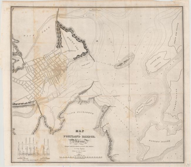
An early and nicely detailed examination of Portla... (full text available to subscribers)
Item Detail
 
  MapMaker:  

John Anderson


  Subject:  Portland, Maine  
  Period/Size:  1833 / 17.9" x 19.9"  (45.5 x 50.6 cm)  
  Color:  Black & White  
  Condition:  (B) Issued folding with scattered foxing, faint offsetting, and a 0.75" tear adjacent to a fold directly above the title. (condition help)  
  Source:   
  References:  Phillips (Maps) p. 717.  
 
 
Sales Information
 
  Price: 

Please register your email to view records, or sign in with email address to see records


  Offered by:  Old World Auctions  
  Catalog:  Auction No. 156 - Antique Maps, Charts, Atlases & Globes (9289)  
  Lot/Item #:  271  
 
  Date:  02/2016  


Antique Maps - Valuation and Pricing, Descriptions, Resources


Home | Information | Search | Register | Contact Us | Site Map

Americana Exchange, Inc. © 1999 - 2024 Americana Exchange, Inc.. All rights reserved. OldMaps.com, the OldMaps.com logo and
AMPR are service marks or registered service marks of Americana Exchange, Inc..