Title:
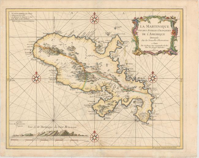
“La Martinique une des Antilles Francoises de l'Amerique Dressee sur les Nouvelles Observations”
Map Maker:
George Louis Le Rouge
This striking chart of Martinique divides the isla... (full text available to subscribers)
| Item Detail |
| |
| |
MapMaker: |
George Louis Le Rouge
|
|
| |
| |
Subject: |
Martinique |
|
| |
Period/Size: |
1753 / 19.4" x 24.5" (49.3 x 62.3 cm)
|
|
| |
Color: |
Colored
|
|
| |
Condition: |
(B+) Attractive color on sturdy, watermarked paper with very light soiling and archivally repaired tears that enters 1.5" into map at bottom near the centerfold and 1" at bottom right. (condition help) |
|
| |
Source: |
Atlas Ameriquain Septentrional... |
|
| |
References: |
|
|
| |
|
|
| Sales Information |
| |
| |
Price: |
|
|
| |
| |
Offered by: |
Old World Auctions |
|
| |
Catalog: |
Auction No. 156 - Antique Maps, Charts, Atlases & Globes (9289) |
|
| |
Lot/Item #: |
377 |
|
| |
| |
Date: |
02/2016
|
|
| |
| |
|
Antique Maps - Valuation and Pricing, Descriptions, Resources |
|
Home |
Information |
Search |
Register |
Contact Us |
Site Map
Americana Exchange, Inc. © 1999 - 2024 Americana Exchange, Inc.. All rights reserved.
OldMaps.com, the OldMaps.com logo and
AMPR are service marks or registered service marks of Americana Exchange, Inc..
|