Title:
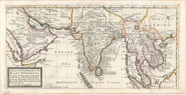
“A Map of the Continent of the East-Indies &c. Containing the Territories, Settlements, and Factories of the Europeans. Explaining What Belongs to England, France, Holland, Denmark, Portugal &c.”
Map Maker:
Herman Moll
This map covers the region from Arabia east to Ind... (full text available to subscribers)
| Item Detail |
| |
| |
MapMaker: |
Herman Moll
|
|
| |
| |
Subject: |
Southern Asia |
|
| |
Period/Size: |
1729 / 8.0" x 16.4" (20.4 x 41.7 cm)
|
|
| |
Color: |
Colored
|
|
| |
Condition: |
(A) Original outline color on paper with a flower watermark. There are a few tiny fold separations confined to the blank margins and closed on verso with archival material. Issued folding and now pressed flat with minor printer's ink residue. (condition help) |
|
| |
Source: |
Atlas Minor: Or, A Set of Sixty-Two New and Correct Maps of All the Parts of the |
|
| |
References: |
Shirley (BL Atlases) T.MOLL-9a #62. |
|
| |
|
|
| Sales Information |
| |
| |
Price: |
|
|
| |
| |
Offered by: |
Old World Auctions |
|
| |
Catalog: |
Auction No. 156 - Antique Maps, Charts, Atlases & Globes (9289) |
|
| |
Lot/Item #: |
714 |
|
| |
| |
Date: |
02/2016
|
|
| |
| |
|
Antique Maps - Valuation and Pricing, Descriptions, Resources |
|
Home |
Information |
Search |
Register |
Contact Us |
Site Map
Americana Exchange, Inc. © 1999 - 2024 Americana Exchange, Inc.. All rights reserved.
OldMaps.com, the OldMaps.com logo and
AMPR are service marks or registered service marks of Americana Exchange, Inc..
|