Title:
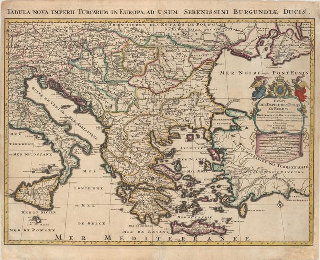
“Estats de l'Empire des Turqs en Europe, Divises Suivant l'Estendue des Beglerbeglicz, ou Gouvernements...”
Map Maker:
Jaillot/Mortier
This map depicts the Turkish Empire in Europe, ext... (full text available to subscribers)
| Item Detail |
| |
| |
MapMaker: |
Jaillot/Mortier
|
|
| |
| |
Subject: |
Balkans |
|
| |
Period/Size: |
1705 / 18.0" x 24.3" (45.8 x 61.8 cm)
|
|
| |
Color: |
Colored
|
|
| |
Condition: |
(B+) A dark impression with original outline color and later color in the cartouche. There is light soiling, a few minor creases at far left, and professional repairs to a centerfold separation at bottom and chips in bottom corners of sheet, with a minor (condition help) |
|
| |
Source: |
|
|
| |
References: |
|
|
| |
|
|
| Sales Information |
| |
| |
Price: |
|
|
| |
| |
Offered by: |
Old World Auctions |
|
| |
Catalog: |
Auction No. 156 - Antique Maps, Charts, Atlases & Globes (9289) |
|
| |
Lot/Item #: |
551 |
|
| |
| |
Date: |
02/2016
|
|
| |
| |
|
Antique Maps - Valuation and Pricing, Descriptions, Resources |
|
Home |
Information |
Search |
Register |
Contact Us |
Site Map
Americana Exchange, Inc. © 1999 - 2024 Americana Exchange, Inc.. All rights reserved.
OldMaps.com, the OldMaps.com logo and
AMPR are service marks or registered service marks of Americana Exchange, Inc..
|