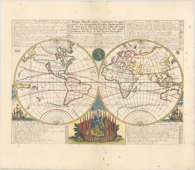
Title:
“Mappe-Monde pour Connoitre les Progres & les Conquestes les Plus Remarquables des Provinces-Unies...”
Map Maker:
Henry Abraham Chatelain
The voyages and discoveries of the Dutch East Indi... (full text available to subscribers)
| Item Detail |
| |
| |
MapMaker: |
Henry Abraham Chatelain
|
|
| |
| |
Subject: |
World |
|
| |
Period/Size: |
1719 / 13.0" x 17.9" (33.1 x 45.5 cm)
|
|
| |
Color: |
Colored
|
|
| |
Condition: |
(A) Attractive color on a bright sheet of watermarked paper with a few tiny spots of foxing, primarily confined to the blank margins. (condition help) |
|
| |
Source: |
Atlas Historique… |
|
| |
References: |
Shirley #447. |
|
| |
|
|
| Sales Information |
| |
| |
Price: |
|
|
| |
| |
Offered by: |
Old World Auctions |
|
| |
Catalog: |
Auction No. 158 - Antique Maps, Charts, Atlases & Globes (9323) |
|
| |
Lot/Item #: |
25 |
|
| |
| |
Date: |
06/2016
|
|
| |
| |
|
Antique Maps - Valuation and Pricing, Descriptions, Resources |
|
Home |
Information |
Search |
Register |
Contact Us |
Site Map
Americana Exchange, Inc. © 1999 - 2024 Americana Exchange, Inc.. All rights reserved.
OldMaps.com, the OldMaps.com logo and
AMPR are service marks or registered service marks of Americana Exchange, Inc..
|