Title:
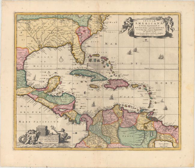
“Insulae Americanae in Oceano Septentrionali ac Regiones Adiacentes, a C. de May Usque ad Lineam Aequinoctialem”
Map Maker:
Visscher/Schenk
This handsome map focuses on the West Indies and c... (full text available to subscribers)
| Item Detail |
| |
| |
MapMaker: |
Visscher/Schenk
|
|
| |
| |
Subject: |
Gulf of Mexico & Caribbean |
|
| |
Period/Size: |
1720 / 18.2" x 22.2" (46.3 x 56.4 cm)
|
|
| |
Color: |
Colored
|
|
| |
Condition: |
(B+) Full original color with light printer's ink residue and minor toning along the centerfold. One short tear in the image has been closed on verso with archival material. There are some minor spots and damp stains confined to the blank margins. (condition help) |
|
| |
Source: |
|
|
| |
References: |
Burden #531; cf. Portinaro & Knirsch #82. |
|
| |
|
|
| Sales Information |
| |
| |
Price: |
|
|
| |
| |
Offered by: |
Old World Auctions |
|
| |
Catalog: |
Auction No. 158 - Antique Maps, Charts, Atlases & Globes (9323) |
|
| |
Lot/Item #: |
165 |
|
| |
| |
Date: |
06/2016
|
|
| |
| |
|
Antique Maps - Valuation and Pricing, Descriptions, Resources |
|
Home |
Information |
Search |
Register |
Contact Us |
Site Map
Americana Exchange, Inc. © 1999 - 2024 Americana Exchange, Inc.. All rights reserved.
OldMaps.com, the OldMaps.com logo and
AMPR are service marks or registered service marks of Americana Exchange, Inc..
|