Title:
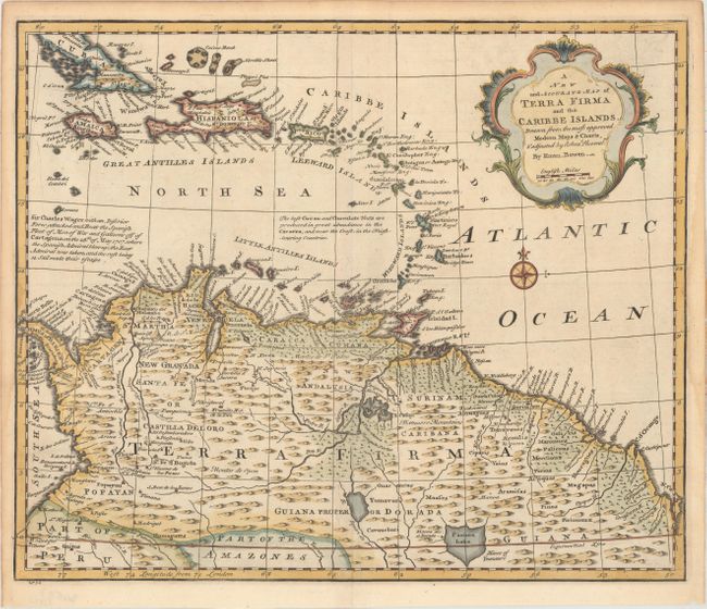
“A New and Accurate Map of Terra Firma and the Caribbe Islands. Drawn from the Most Approved Modern Maps & Charts, & Adjusted by Astonl. Observatns.”
Map Maker:
Emanuel Bowen
This uncommon map covers most of the Caribbean fro... (full text available to subscribers)
| Item Detail |
| |
| |
MapMaker: |
Emanuel Bowen
|
|
| |
| |
Subject: |
Northern South America & Lesser Antilles |
|
| |
Period/Size: |
1747 / 14.0" x 16.8" (35.6 x 42.7 cm)
|
|
| |
Color: |
Colored
|
|
| |
Condition: |
(A) There are light damp stains in the left and right margins that just enter the neatline. (condition help) |
|
| |
Source: |
|
|
| |
References: |
|
|
| |
|
|
| Sales Information |
| |
| |
Price: |
|
|
| |
| |
Offered by: |
Old World Auctions |
|
| |
Catalog: |
Auction No. 158 - Antique Maps, Charts, Atlases & Globes (9323) |
|
| |
Lot/Item #: |
184 |
|
| |
| |
Date: |
06/2016
|
|
| |
| |
|
Antique Maps - Valuation and Pricing, Descriptions, Resources |
|
Home |
Information |
Search |
Register |
Contact Us |
Site Map
Americana Exchange, Inc. © 1999 - 2024 Americana Exchange, Inc.. All rights reserved.
OldMaps.com, the OldMaps.com logo and
AMPR are service marks or registered service marks of Americana Exchange, Inc..
|