Title:
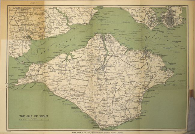
“A Pictorial and Descriptive Guide to the Isle of Wight, in Six Sections, with Walks and Excursions by Road, Rail and Steamer from Each Centre...”
Map Maker:
Infrequent Publ. - Local & State Maps
This detailed guidebook of the Isle of Wight inclu... (full text available to subscribers)
| Item Detail |
| |
| |
MapMaker: |
Infrequent Publ. - Local & State Maps
|
|
| |
| |
Subject: |
Books with maps, Isle of Wight, England |
|
| |
Period/Size: |
1908 / 6.8" x 4.3" (17.3 x 11.0 cm)
|
|
| |
Color: |
Colored
|
|
| |
Condition: |
(B+) Light toning with minor soiling. The map of the Isle of Wight has a short binding tear. The hinges are perished and the covers are lightly soiled. (condition help) |
|
| |
Source: |
|
|
| |
References: |
|
|
| |
|
|
| Sales Information |
| |
| |
Price: |
|
|
| |
| |
Offered by: |
Old World Auctions |
|
| |
Catalog: |
Auction No. 158 - Antique Maps, Charts, Atlases & Globes (9323) |
|
| |
Lot/Item #: |
241 |
|
| |
| |
Date: |
06/2016
|
|
| |
| |
|
Antique Maps - Valuation and Pricing, Descriptions, Resources |
|
Home |
Information |
Search |
Register |
Contact Us |
Site Map
Americana Exchange, Inc. © 1999 - 2024 Americana Exchange, Inc.. All rights reserved.
OldMaps.com, the OldMaps.com logo and
AMPR are service marks or registered service marks of Americana Exchange, Inc..
|