Title:
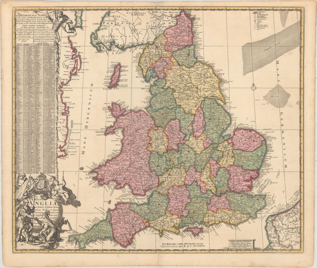
“Regni Angliae Nova Tabula, Exhibens Principatum Walliae &, Aliarum Provinciarum, Civitatum, Oppidorum, una cum Itineribus ab uno in Aliam Civitatem”
Map Maker:
Reiner and Joshua Ottens
This handsome map of England and Wales was origina... (full text available to subscribers)
| Item Detail |
| |
| |
MapMaker: |
Reiner and Joshua Ottens
|
|
| |
| |
Subject: |
England & Wales |
|
| |
Period/Size: |
1730 / 19.5" x 23.0" (49.6 x 58.5 cm)
|
|
| |
Color: |
Colored
|
|
| |
Condition: |
(A) Superb, full original color with short centerfold separations at top and bottom that have been archivally repaired and a tiny hole along the coast of Ireland. (condition help) |
|
| |
Source: |
|
|
| |
References: |
Shirley (BI to 1750) De Ram 1 #3. |
|
| |
|
|
| Sales Information |
| |
| |
Price: |
|
|
| |
| |
Offered by: |
Old World Auctions |
|
| |
Catalog: |
Auction No. 158 - Antique Maps, Charts, Atlases & Globes (9323) |
|
| |
Lot/Item #: |
250 |
|
| |
| |
Date: |
06/2016
|
|
| |
| |
|
Antique Maps - Valuation and Pricing, Descriptions, Resources |
|
Home |
Information |
Search |
Register |
Contact Us |
Site Map
Americana Exchange, Inc. © 1999 - 2024 Americana Exchange, Inc.. All rights reserved.
OldMaps.com, the OldMaps.com logo and
AMPR are service marks or registered service marks of Americana Exchange, Inc..
|