Title:
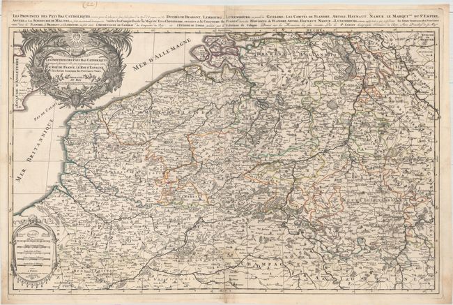
“Les Provinces des Pays-Bas Catholiques Distinguees Suivant qu' elles sont Presentement Partagees Entre le Roy de France, le Roy d'Espagne, et les Estats Generaux des Provinces-Unies”
Map Maker:
Sanson/Jaillot
This splendid, large map of the Low Countries cove... (full text available to subscribers)
| Item Detail |
| |
| |
MapMaker: |
Sanson/Jaillot
|
|
| |
| |
Subject: |
Belgium & Luxembourg |
|
| |
Period/Size: |
1696 / 21.3" x 34.5" (54.1 x 87.7 cm)
|
|
| |
Color: |
Colored
|
|
| |
Condition: |
(B+) Original outline color with minor soiling, an archivally repaired centerfold separation that enters less than 1" into map at bottom, and some small worm holes in bottom corners that have been professionally repaired and only one of which passes the n (condition help) |
|
| |
Source: |
Atlas Nouveau |
|
| |
References: |
Pastoureau, JAILLOT I E [19]. |
|
| |
|
|
| Sales Information |
| |
| |
Price: |
|
|
| |
| |
Offered by: |
Old World Auctions |
|
| |
Catalog: |
Auction No. 158 - Antique Maps, Charts, Atlases & Globes (9323) |
|
| |
Lot/Item #: |
283 |
|
| |
| |
Date: |
06/2016
|
|
| |
| |
|
Antique Maps - Valuation and Pricing, Descriptions, Resources |
|
Home |
Information |
Search |
Register |
Contact Us |
Site Map
Americana Exchange, Inc. © 1999 - 2024 Americana Exchange, Inc.. All rights reserved.
OldMaps.com, the OldMaps.com logo and
AMPR are service marks or registered service marks of Americana Exchange, Inc..
|