Title:
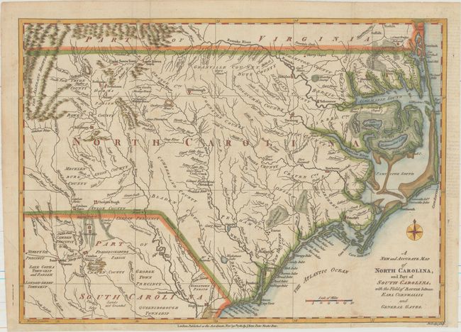
“A New and Accurate Map of North Carolina, and Part of South Carolina, with the Field of Battle Between Earl Cornwallis and General Gates”
Map Maker:
John Lodge
This scarce map of the Carolinas, published during... (full text available to subscribers)
| Item Detail |
| |
| |
MapMaker: |
John Lodge
|
|
| |
| |
Subject: |
North Carolina & South Carolina |
|
| |
Period/Size: |
1780 / 10.8" x 15.1" (27.5 x 38.4 cm)
|
|
| |
Color: |
Colored
|
|
| |
Condition: |
(B+) Issued folding, now flattened with light offsetting at right from an opposing page of text and a few short fold separations confined to the blank margins. A binding trim at right has been replaced with old paper. (condition help) |
|
| |
Source: |
Political Magazine |
|
| |
References: |
Jolly #POL-16. |
|
| |
|
|
| Sales Information |
| |
| |
Price: |
|
|
| |
| |
Offered by: |
Old World Auctions |
|
| |
Catalog: |
Auction No. 159 - Antique Maps, Charts, Atlases & Globes (9324) |
|
| |
Lot/Item #: |
200 |
|
| |
| |
Date: |
09/2016
|
|
| |
| |
|
Antique Maps - Valuation and Pricing, Descriptions, Resources |
|
Home |
Information |
Search |
Register |
Contact Us |
Site Map
Americana Exchange, Inc. © 1999 - 2024 Americana Exchange, Inc.. All rights reserved.
OldMaps.com, the OldMaps.com logo and
AMPR are service marks or registered service marks of Americana Exchange, Inc..
|