Title:
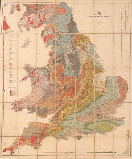
“Geological Map of England & Wales Reduced Chiefly from the Ordnance and Geological Surveys...”
Map Maker:
Archibald Geikie
This superb, large-scale thematic map covers Engla... (full text available to subscribers)
| Item Detail |
| |
| |
MapMaker: |
Archibald Geikie
|
|
| |
| |
Subject: |
England & Wales |
|
| |
Period/Size: |
1897 / 40.0" x 33.8" (101.6 x 85.9 cm)
|
|
| |
Color: |
Colored
|
|
| |
Condition: |
(B+) Light soiling on the map. There is light wear to the covers and there are short tears to the title page of the explanatory notes that have been closed with archival tape on verso. (condition help) |
|
| |
Source: |
|
|
| |
References: |
|
|
| |
|
|
| Sales Information |
| |
| |
Price: |
|
|
| |
| |
Offered by: |
Old World Auctions |
|
| |
Catalog: |
Auction No. 159 - Antique Maps, Charts, Atlases & Globes (9324) |
|
| |
Lot/Item #: |
417 |
|
| |
| |
Date: |
09/2016
|
|
| |
| |
|
Antique Maps - Valuation and Pricing, Descriptions, Resources |
|
Home |
Information |
Search |
Register |
Contact Us |
Site Map
Americana Exchange, Inc. © 1999 - 2024 Americana Exchange, Inc.. All rights reserved.
OldMaps.com, the OldMaps.com logo and
AMPR are service marks or registered service marks of Americana Exchange, Inc..
|