Title:
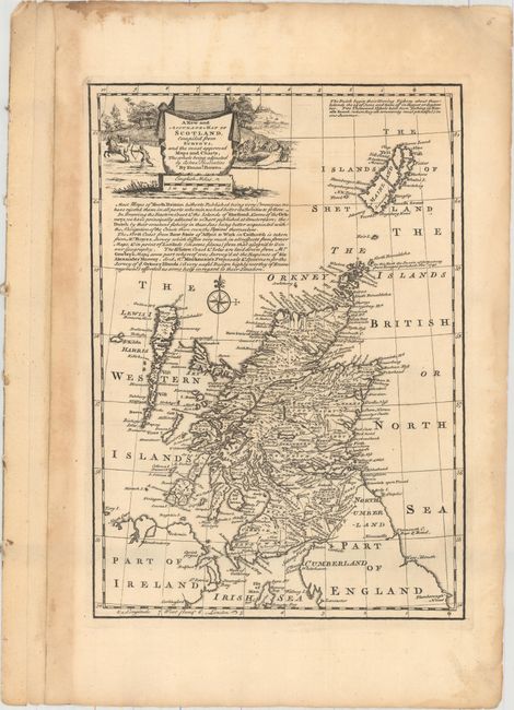
“A New and Accurate Map of Scotland. Compiled from Surveys, and the Most Approved Maps and Charts. The Whole Being Adjusted by Astronl. Observation”
Map Maker:
Emanuel Bowen
This map covers all of Scotland, extending north t... (full text available to subscribers)
| Item Detail |
| |
| |
MapMaker: |
Emanuel Bowen
|
|
| |
| |
Subject: |
Scotland |
|
| |
Period/Size: |
1747 / 12.5" x 8.8" (31.8 x 22.4 cm)
|
|
| |
Color: |
Black & White
|
|
| |
Condition: |
(B+) A dark impression with a few faint spots in the image and some toning and damp staining confined to the blank margins. (condition help) |
|
| |
Source: |
A Complete System of Geography |
|
| |
References: |
|
|
| |
|
|
| Sales Information |
| |
| |
Price: |
|
|
| |
| |
Offered by: |
Old World Auctions |
|
| |
Catalog: |
Auction No. 159 - Antique Maps, Charts, Atlases & Globes (9324) |
|
| |
Lot/Item #: |
422 |
|
| |
| |
Date: |
09/2016
|
|
| |
| |
|
Antique Maps - Valuation and Pricing, Descriptions, Resources |
|
Home |
Information |
Search |
Register |
Contact Us |
Site Map
Americana Exchange, Inc. © 1999 - 2024 Americana Exchange, Inc.. All rights reserved.
OldMaps.com, the OldMaps.com logo and
AMPR are service marks or registered service marks of Americana Exchange, Inc..
|