Title:
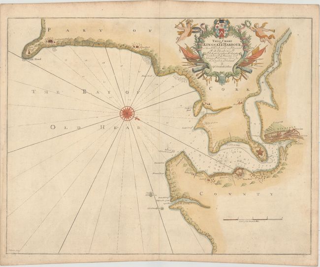
“This Chart of Kingsale Harbour Is Humbly Dedicated and Presented to the Right Honble. Sr. Robert Southwell Knight...”
Map Maker:
Greenvile Collins
This handsome chart focuses on a portion of County... (full text available to subscribers)
| Item Detail |
| |
| |
MapMaker: |
Greenvile Collins
|
|
| |
| |
Subject: |
Southwest Ireland |
|
| |
Period/Size: |
1693 / 17.7" x 22.5" (45.0 x 57.2 cm)
|
|
| |
Color: |
Colored
|
|
| |
Condition: |
(B+) Heavy paper with very light surface soil. (condition help) |
|
| |
Source: |
Great-Britain's Coasting Pilot |
|
| |
References: |
Shirley (BL Atlases) M.COLL-1c #29; Verner (MCC-58) #49. |
|
| |
|
|
| Sales Information |
| |
| |
Price: |
|
|
| |
| |
Offered by: |
Old World Auctions |
|
| |
Catalog: |
Auction No. 159 - Antique Maps, Charts, Atlases & Globes (9324) |
|
| |
Lot/Item #: |
430 |
|
| |
| |
Date: |
09/2016
|
|
| |
| |
|
Antique Maps - Valuation and Pricing, Descriptions, Resources |
|
Home |
Information |
Search |
Register |
Contact Us |
Site Map
Americana Exchange, Inc. © 1999 - 2024 Americana Exchange, Inc.. All rights reserved.
OldMaps.com, the OldMaps.com logo and
AMPR are service marks or registered service marks of Americana Exchange, Inc..
|