Title:
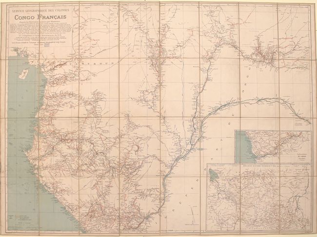
“Service Geographique des Colonies Congo Francais d'Apres les Itineraires Releves par Messieurs”
Map Maker:
Jules Andre Arthur Hansen
This large, highly detailed map of western Africa ... (full text available to subscribers)
| Item Detail |
| |
| |
MapMaker: |
Jules Andre Arthur Hansen
|
|
| |
| |
Subject: |
Western Africa |
|
| |
Period/Size: |
1895 / 36.3" x 49.0" (92.2 x 124.5 cm)
|
|
| |
Color: |
Colored
|
|
| |
Condition: |
(B+) Issued folding with light soiling primarily along the left side of the map. Slipcase is moderately worn and chipped from use. (condition help) |
|
| |
Source: |
|
|
| |
References: |
|
|
| |
|
|
| Sales Information |
| |
| |
Price: |
|
|
| |
| |
Offered by: |
Old World Auctions |
|
| |
Catalog: |
Auction No. 159 - Antique Maps, Charts, Atlases & Globes (9324) |
|
| |
Lot/Item #: |
701 |
|
| |
| |
Date: |
09/2016
|
|
| |
| |
|
Antique Maps - Valuation and Pricing, Descriptions, Resources |
|
Home |
Information |
Search |
Register |
Contact Us |
Site Map
Americana Exchange, Inc. © 1999 - 2024 Americana Exchange, Inc.. All rights reserved.
OldMaps.com, the OldMaps.com logo and
AMPR are service marks or registered service marks of Americana Exchange, Inc..
|