Title:
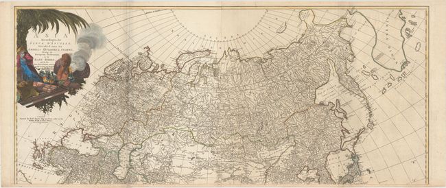
“Asia According to the Sieur d'Anville, Divided into Its Empires Kingdoms & States, Shewing the European Settlements in the East Indies, and All the New Discoveries, Made by the Russians the Dutch and the English”
Map Maker:
Robert Sayer
These are the upper two sheets of the superb, four... (full text available to subscribers)
| Item Detail |
| |
| |
MapMaker: |
Robert Sayer
|
|
| |
| |
Subject: |
Northern Asia |
|
| |
Period/Size: |
1772 / 20.3" x 47.1" (51.6 x 119.7 cm)
|
|
| |
Color: |
Colored
|
|
| |
Condition: |
(B+) A fine impression on watermarked paper with light scattered foxing that is more prominent on the eastern sheet, minor offsetting, and a few extraneous creases. A fold separation at bottom left has been closed on verso with old paper. (condition help) |
|
| |
Source: |
|
|
| |
References: |
|
|
| |
|
|
| Sales Information |
| |
| |
Price: |
|
|
| |
| |
Offered by: |
Old World Auctions |
|
| |
Catalog: |
Auction No. 159 - Antique Maps, Charts, Atlases & Globes (9324) |
|
| |
Lot/Item #: |
628 |
|
| |
| |
Date: |
09/2016
|
|
| |
| |
|
Antique Maps - Valuation and Pricing, Descriptions, Resources |
|
Home |
Information |
Search |
Register |
Contact Us |
Site Map
Americana Exchange, Inc. © 1999 - 2024 Americana Exchange, Inc.. All rights reserved.
OldMaps.com, the OldMaps.com logo and
AMPR are service marks or registered service marks of Americana Exchange, Inc..
|