Title:
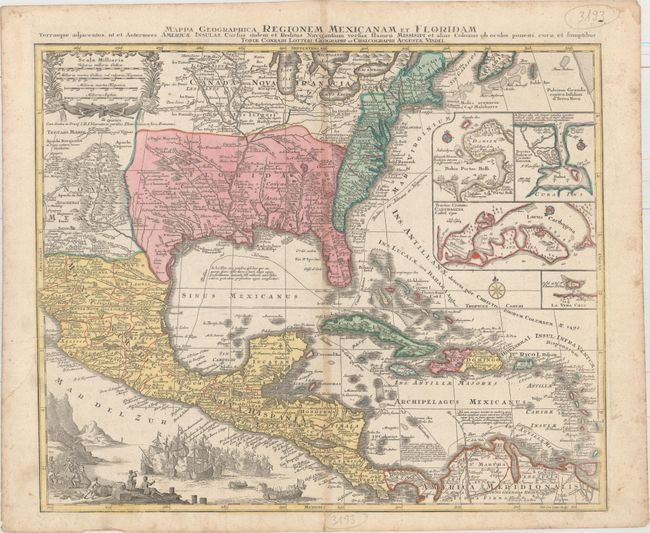
“Mappa Geographica Regionem Mexicanam et Floridam Terrasque Adjacentes, ut et Anteriores Americae Insulas, Cursus Itidem et Reditus Navigantium Versus Flumen Missisipi...”
Map Maker:
Seutter/Lotter
This is Mathias Seutter's decorative and beautiful... (full text available to subscribers)
| Item Detail |
| |
| |
MapMaker: |
Seutter/Lotter
|
|
| |
| |
Subject: |
Colonial Eastern North America & West Indies |
|
| |
Period/Size: |
1760 / 18.8" x 22.8" (47.8 x 58.0 cm)
|
|
| |
Color: |
Colored
|
|
| |
Condition: |
(B+) Full original color on watermarked paper with light soiling and toning along the centerfold. There is an archivally repaired centerfold separation that enters less than 1" into image at bottom. (condition help) |
|
| |
Source: |
|
|
| |
References: |
Martin & Martin, p. 93, plt. 18. |
|
| |
|
|
| Sales Information |
| |
| |
Price: |
|
|
| |
| |
Offered by: |
Old World Auctions |
|
| |
Catalog: |
Auction No. 160 - Antique Maps, Charts, Atlases & Globes (9325) |
|
| |
Lot/Item #: |
120 |
|
| |
| |
Date: |
11/2016
|
|
| |
| |
|
Antique Maps - Valuation and Pricing, Descriptions, Resources |
|
Home |
Information |
Search |
Register |
Contact Us |
Site Map
Americana Exchange, Inc. © 1999 - 2024 Americana Exchange, Inc.. All rights reserved.
OldMaps.com, the OldMaps.com logo and
AMPR are service marks or registered service marks of Americana Exchange, Inc..
|