Title:
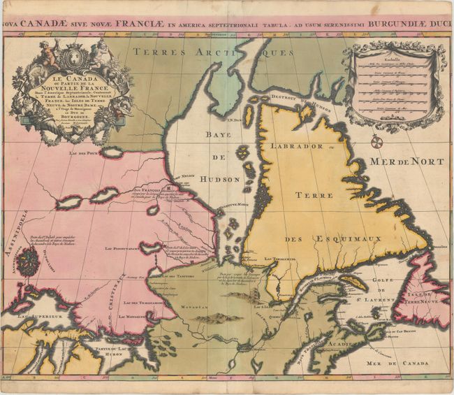
“Le Canada ou Partie de la Nouvelle France dans l'Amerique Septentrionale, Contenant la Terre de Labrador, la Nouvelle France, les Isles de Terre Neuve, de Nostre Dame, etc.”
Map Maker:
Alexis-Hubert Jaillot
This bold map includes some cartographically impor... (full text available to subscribers)
| Item Detail |
| |
| |
MapMaker: |
Alexis-Hubert Jaillot
|
|
| |
| |
Subject: |
Eastern Canada |
|
| |
Period/Size: |
1696 / 18.1" x 23.6" (46.0 x 60.0 cm)
|
|
| |
Color: |
Colored
|
|
| |
Condition: |
(B) Sharp impression with bold original color, light soiling, and one tiny abrasion in the map along the centerfold. The side margins were trimmed by the binder to fit into an atlas, with loss of a portion of the border and the first and last letter in (condition help) |
|
| |
Source: |
|
|
| |
References: |
Kershaw #174. |
|
| |
|
|
| Sales Information |
| |
| |
Price: |
|
|
| |
| |
Offered by: |
Old World Auctions |
|
| |
Catalog: |
Auction No. 160 - Antique Maps, Charts, Atlases & Globes (9325) |
|
| |
Lot/Item #: |
127 |
|
| |
| |
Date: |
11/2016
|
|
| |
| |
|
Antique Maps - Valuation and Pricing, Descriptions, Resources |
|
Home |
Information |
Search |
Register |
Contact Us |
Site Map
Americana Exchange, Inc. © 1999 - 2024 Americana Exchange, Inc.. All rights reserved.
OldMaps.com, the OldMaps.com logo and
AMPR are service marks or registered service marks of Americana Exchange, Inc..
|