Title:
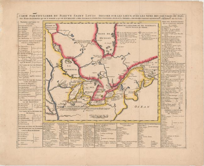
“Carte Particuliere du Fleuve Saint Louis Dressee sur les Lieux avec les Noms des Sauvages du Pais...”
Map Maker:
Henry Abraham Chatelain
This fascinating and oddly inaccurate map of the G... (full text available to subscribers)
| Item Detail |
| |
| |
MapMaker: |
Henry Abraham Chatelain
|
|
| |
| |
Subject: |
Colonial Northeastern United States & Canada, Great Lakes |
|
| |
Period/Size: |
1719 / 14.3" x 18.0" (36.4 x 45.8 cm)
|
|
| |
Color: |
Colored
|
|
| |
Condition: |
(B+) A crisp impression issued folding with light scattered foxing. There are a few short fold separations and light soiling in the blank margins. (condition help) |
|
| |
Source: |
Atlas Historique |
|
| |
References: |
Kershaw #307. |
|
| |
|
|
| Sales Information |
| |
| |
Price: |
|
|
| |
| |
Offered by: |
Old World Auctions |
|
| |
Catalog: |
Auction No. 160 - Antique Maps, Charts, Atlases & Globes (9325) |
|
| |
Lot/Item #: |
134 |
|
| |
| |
Date: |
11/2016
|
|
| |
| |
|
Antique Maps - Valuation and Pricing, Descriptions, Resources |
|
Home |
Information |
Search |
Register |
Contact Us |
Site Map
Americana Exchange, Inc. © 1999 - 2024 Americana Exchange, Inc.. All rights reserved.
OldMaps.com, the OldMaps.com logo and
AMPR are service marks or registered service marks of Americana Exchange, Inc..
|