Title:
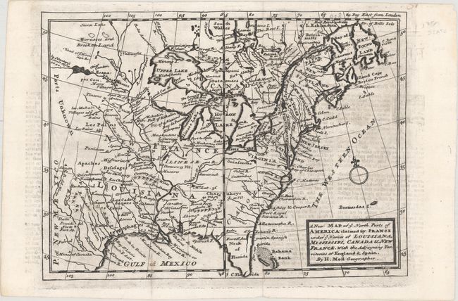
“A New Map of ye North Parts of America Claimed by France under ye Names of Louisiana, Mississipi, Canada & New France, with the Adjoyning Territories of England & Spain”
Map Maker:
Herman Moll
This handsome map is a reduced version of a portio... (full text available to subscribers)
| Item Detail |
| |
| |
MapMaker: |
Herman Moll
|
|
| |
| |
Subject: |
Colonial Eastern United States & Canada |
|
| |
Period/Size: |
1735 / 7.8" x 10.8" (19.9 x 27.5 cm)
|
|
| |
Color: |
Black & White
|
|
| |
Condition: |
(B+) A dark impression on a clean sheet with some light offsetting from an opposing page of text. Issued folding. (condition help) |
|
| |
Source: |
|
|
| |
References: |
cf. McCorkle #729-3. |
|
| |
|
|
| Sales Information |
| |
| |
Price: |
|
|
| |
| |
Offered by: |
Old World Auctions |
|
| |
Catalog: |
Auction No. 160 - Antique Maps, Charts, Atlases & Globes (9325) |
|
| |
Lot/Item #: |
148 |
|
| |
| |
Date: |
11/2016
|
|
| |
| |
|
Antique Maps - Valuation and Pricing, Descriptions, Resources |
|
Home |
Information |
Search |
Register |
Contact Us |
Site Map
Americana Exchange, Inc. © 1999 - 2024 Americana Exchange, Inc.. All rights reserved.
OldMaps.com, the OldMaps.com logo and
AMPR are service marks or registered service marks of Americana Exchange, Inc..
|