Title:
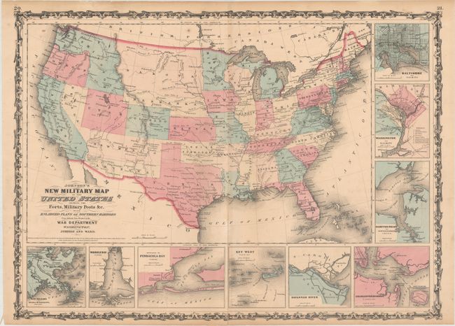
“Johnson's New Military Map of the United States Showing the Forts, Military Posts &c. with Enlarged Plans of Southern Harbors...”
Map Maker:
Johnson & Ward
This is the more desirable issue of this Civil ... (full text available to subscribers)
| Item Detail |
| |
| |
MapMaker: |
Johnson & Ward
|
|
| |
| |
Subject: |
United States, Civil War |
|
| |
Period/Size: |
1861 / 17.0" x 23.5" (43.2 x 59.7 cm)
|
|
| |
Color: |
Colored
|
|
| |
Condition: |
(B) There is a long centerfold separation running nearly the length of the map and an adjacent short tear near the middle of the map image that have been closed on verso with a combination of old paper and hinge tape. Light scattered foxing with a few mi (condition help) |
|
| |
Source: |
|
|
| |
References: |
|
|
| |
|
|
| Sales Information |
| |
| |
Price: |
|
|
| |
| |
Offered by: |
Old World Auctions |
|
| |
Catalog: |
Auction No. 160 - Antique Maps, Charts, Atlases & Globes (9325) |
|
| |
Lot/Item #: |
166 |
|
| |
| |
Date: |
11/2016
|
|
| |
| |
|
Antique Maps - Valuation and Pricing, Descriptions, Resources |
|
Home |
Information |
Search |
Register |
Contact Us |
Site Map
Americana Exchange, Inc. © 1999 - 2024 Americana Exchange, Inc.. All rights reserved.
OldMaps.com, the OldMaps.com logo and
AMPR are service marks or registered service marks of Americana Exchange, Inc..
|