Title:
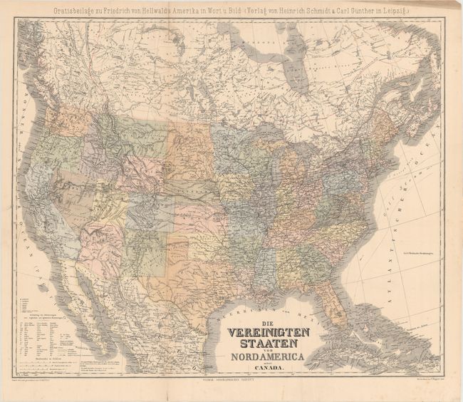
“Die Vereinigten Staaten von Nord America nebst Canada”
Map Maker:
Heinrich C. Kiepert
Large and very detailed German map that covers the... (full text available to subscribers)
| Item Detail |
| |
| |
MapMaker: |
Heinrich C. Kiepert
|
|
| |
| |
Subject: |
United States |
|
| |
Period/Size: |
1875 / 20.7" x 25.0" (52.6 x 63.5 cm)
|
|
| |
Color: |
Colored
|
|
| |
Condition: |
(B) Issued folding with a 9" edge tear that has been closed on verso with archival tape. There is minor creasing and a few fold separations have also been closed on verso with archival tape. (condition help) |
|
| |
Source: |
Geographisches Institut Weimar |
|
| |
References: |
|
|
| |
|
|
| Sales Information |
| |
| |
Price: |
|
|
| |
| |
Offered by: |
Old World Auctions |
|
| |
Catalog: |
Auction No. 160 - Antique Maps, Charts, Atlases & Globes (9325) |
|
| |
Lot/Item #: |
170 |
|
| |
| |
Date: |
11/2016
|
|
| |
| |
|
Antique Maps - Valuation and Pricing, Descriptions, Resources |
|
Home |
Information |
Search |
Register |
Contact Us |
Site Map
Americana Exchange, Inc. © 1999 - 2024 Americana Exchange, Inc.. All rights reserved.
OldMaps.com, the OldMaps.com logo and
AMPR are service marks or registered service marks of Americana Exchange, Inc..
|