Title:
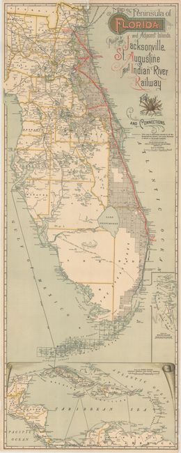
“Map of the Peninsula of Florida and Adjacent Islands”
Map Maker:
Matthews-Northrup Co
This early edition map shows the Jacksonville, St.... (full text available to subscribers)
| Item Detail |
| |
| |
MapMaker: |
Matthews-Northrup Co
|
|
| |
| |
Subject: |
Florida |
|
| |
Period/Size: |
1893 / 39.8" x 15.6" (101.1 x 39.7 cm)
|
|
| |
Color: |
Colored
|
|
| |
Condition: |
(B) Issued folding with several short splits at fold intersections. There is minor loss along a horizontal fold near Titusville as well as a small chip near the top border above Jacksonville. Paper wrappers are very good. (condition help) |
|
| |
Source: |
|
|
| |
References: |
|
|
| |
|
|
| Sales Information |
| |
| |
Price: |
|
|
| |
| |
Offered by: |
Old World Auctions |
|
| |
Catalog: |
Auction No. 160 - Antique Maps, Charts, Atlases & Globes (9325) |
|
| |
Lot/Item #: |
266 |
|
| |
| |
Date: |
11/2016
|
|
| |
| |
|
Antique Maps - Valuation and Pricing, Descriptions, Resources |
|
Home |
Information |
Search |
Register |
Contact Us |
Site Map
Americana Exchange, Inc. © 1999 - 2024 Americana Exchange, Inc.. All rights reserved.
OldMaps.com, the OldMaps.com logo and
AMPR are service marks or registered service marks of Americana Exchange, Inc..
|