Title:
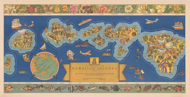
“The Dole Map of the Hawaiian Islands U.S.A. Being a Descriptive Portrayal of the History, Transportation, Industries and Geography of the Territory of Hawaii, U.S.A.”
Map Maker:
Infrequent Publ. - Anthropomorphic & Cartoon Maps
This vivid and graphic map of the Hawaiian islands... (full text available to subscribers)
| Item Detail |
| |
| |
MapMaker: |
Infrequent Publ. - Anthropomorphic & Cartoon Maps
|
|
| |
| |
Subject: |
Hawaii |
|
| |
Period/Size: |
1937 / 17.4" x 35.5" (44.2 x 90.2 cm)
|
|
| |
Color: |
Colored
|
|
| |
Condition: |
(A) A clean and bright example with a few tiny spots and one pinhole in the top blank margin. (condition help) |
|
| |
Source: |
|
|
| |
References: |
|
|
| |
|
|
| Sales Information |
| |
| |
Price: |
|
|
| |
| |
Offered by: |
Old World Auctions |
|
| |
Catalog: |
Auction No. 160 - Antique Maps, Charts, Atlases & Globes (9325) |
|
| |
Lot/Item #: |
279 |
|
| |
| |
Date: |
11/2016
|
|
| |
| |
|
Antique Maps - Valuation and Pricing, Descriptions, Resources |
|
Home |
Information |
Search |
Register |
Contact Us |
Site Map
Americana Exchange, Inc. © 1999 - 2024 Americana Exchange, Inc.. All rights reserved.
OldMaps.com, the OldMaps.com logo and
AMPR are service marks or registered service marks of Americana Exchange, Inc..
|