Title:
“Geological Illustrations Accompanying the First Report of Philip T. Tyson State-Agricultural-Chemist of the State of Maryland”
Map Maker:
Philip T. Tyson
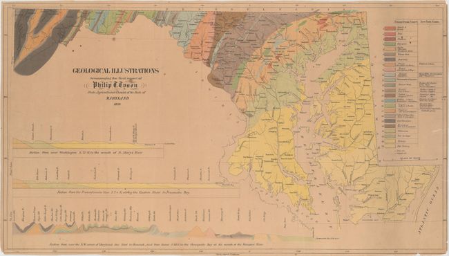
This is the first geological map of Maryland and o... (full text available to subscribers)
| Item Detail |
| |
| |
MapMaker: |
Philip T. Tyson
|
|
| |
| |
Subject: |
Maryland |
|
| |
Period/Size: |
1859 / 14.6" x 25.9" (37.1 x 65.8 cm)
|
|
| |
Color: |
Colored
|
|
| |
Condition: |
(B) Uniform light toning with a few minor spots and several small edge tears and separations that enter the neatline no more than 1". (condition help) |
|
| |
Source: |
|
|
| |
References: |
Marcou & Marcou #283. |
|
| |
|
|
| Sales Information |
| |
| |
Price: |
|
|
| |
| |
Offered by: |
Old World Auctions |
|
| |
Catalog: |
Auction No. 160 - Antique Maps, Charts, Atlases & Globes (9325) |
|
| |
Lot/Item #: |
291 |
|
| |
| |
Date: |
11/2016
|
|
| |
| |
|
Antique Maps - Valuation and Pricing, Descriptions, Resources |
|
Home |
Information |
Search |
Register |
Contact Us |
Site Map
Americana Exchange, Inc. © 1999 - 2024 Americana Exchange, Inc.. All rights reserved.
OldMaps.com, the OldMaps.com logo and
AMPR are service marks or registered service marks of Americana Exchange, Inc..
|