Title:
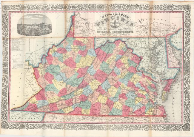
“Map of the State of Virginia Containing the Counties, Principal Towns, Railroads Rivers, Canals & All Other Internal Improvements”
Map Maker:
Leopold von Bucholtz
This first and only edition map of Virginia by Lud... (full text available to subscribers)
| Item Detail |
| |
| |
MapMaker: |
Leopold von Bucholtz
|
|
| |
| |
Subject: |
Virginia |
|
| |
Period/Size: |
1858 / 25.5" x 37.8" (64.8 x 96.1 cm)
|
|
| |
Color: |
Colored
|
|
| |
Condition: |
(B+) Issued folding with several short splits at fold intersections and an edge tear at left that enters 1.5" into the image and has been closed on verso with archival tissue. There are five tiny holes along two folds - three near the "R" of Virginia in (condition help) |
|
| |
Source: |
|
|
| |
References: |
Phillips (Maps) p. 988; Rumsey #4905; cf. Stephenson (Civil War) #475.5; cf. Wooldridge #254. |
|
| |
|
|
| Sales Information |
| |
| |
Price: |
|
|
| |
| |
Offered by: |
Old World Auctions |
|
| |
Catalog: |
Auction No. 160 - Antique Maps, Charts, Atlases & Globes (9325) |
|
| |
Lot/Item #: |
336 |
|
| |
| |
Date: |
11/2016
|
|
| |
| |
|
Antique Maps - Valuation and Pricing, Descriptions, Resources |
|
Home |
Information |
Search |
Register |
Contact Us |
Site Map
Americana Exchange, Inc. © 1999 - 2024 Americana Exchange, Inc.. All rights reserved.
OldMaps.com, the OldMaps.com logo and
AMPR are service marks or registered service marks of Americana Exchange, Inc..
|