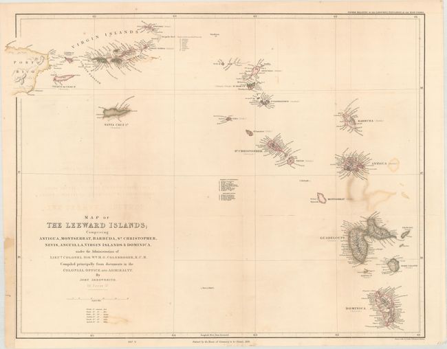
Title:
“Map of the Leeward Islands; Comprising Antiqua, Montserrat, Barbuda, St. Christopher, Nevis, Anguilla, Virgin Islands & Dominica…”
Map Maker:
John Arrowsmith
A colorful and precisely engraved map of the Leewa... (full text available to subscribers)
| Item Detail |
| |
| |
MapMaker: |
John Arrowsmith
|
|
| |
| |
Subject: |
Lesser Antilles |
|
| |
Period/Size: |
1839 / 18.3" x 23.0" (46.5 x 58.5 cm)
|
|
| |
Color: |
Colored
|
|
| |
Condition: |
(B) Issued folding, now pressed and backed with archival tissue, repairing several long fold separations. There is a little title offsetting and color offsetting from Guadeloupe. Binding trim at left, as issued, with paper laid in to accommodate framing (condition help) |
|
| |
Source: |
Papers Relating to the Labouring Population of the West Indies |
|
| |
References: |
|
|
| |
|
|
| Sales Information |
| |
| |
Price: |
|
|
| |
| |
Offered by: |
Old World Auctions |
|
| |
Catalog: |
Auction No. 160 - Antique Maps, Charts, Atlases & Globes (9325) |
|
| |
Lot/Item #: |
408 |
|
| |
| |
Date: |
11/2016
|
|
| |
| |
|
Antique Maps - Valuation and Pricing, Descriptions, Resources |
|
Home |
Information |
Search |
Register |
Contact Us |
Site Map
Americana Exchange, Inc. © 1999 - 2024 Americana Exchange, Inc.. All rights reserved.
OldMaps.com, the OldMaps.com logo and
AMPR are service marks or registered service marks of Americana Exchange, Inc..
|