Title:
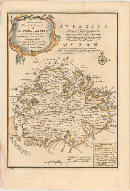
“A New and Accurate Map of the Island of Antigua or Antego, Taken from Surveys, and Adjusted by Astronl. Observations. Containing All the Towns, Parish Churches, Forts, Castles, Windmills, Roads &c.”
Map Maker:
Emanuel Bowen
This attractive small map of Antigua provides a co... (full text available to subscribers)
| Item Detail |
| |
| |
MapMaker: |
Emanuel Bowen
|
|
| |
| |
Subject: |
Antigua |
|
| |
Period/Size: |
1747 / 12.7" x 9.1" (32.3 x 23.2 cm)
|
|
| |
Color: |
Colored
|
|
| |
Condition: |
(A) A crisp impression with a hint of toning and two small chips along the left edge of the sheet that have been professionally repaired. (condition help) |
|
| |
Source: |
A Complete System of Geography... |
|
| |
References: |
Tooley (MCC-55) #20, pl.7. |
|
| |
|
|
| Sales Information |
| |
| |
Price: |
|
|
| |
| |
Offered by: |
Old World Auctions |
|
| |
Catalog: |
Auction No. 160 - Antique Maps, Charts, Atlases & Globes (9325) |
|
| |
Lot/Item #: |
409 |
|
| |
| |
Date: |
11/2016
|
|
| |
| |
|
Antique Maps - Valuation and Pricing, Descriptions, Resources |
|
Home |
Information |
Search |
Register |
Contact Us |
Site Map
Americana Exchange, Inc. © 1999 - 2024 Americana Exchange, Inc.. All rights reserved.
OldMaps.com, the OldMaps.com logo and
AMPR are service marks or registered service marks of Americana Exchange, Inc..
|