Title:
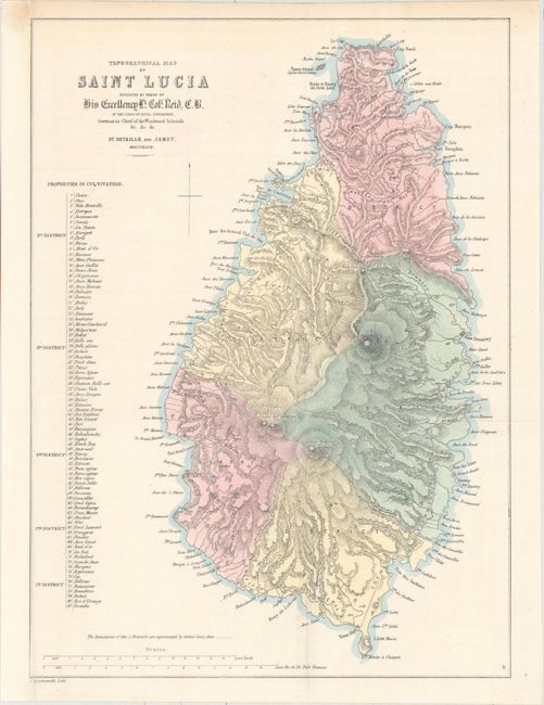
“Topographical Map of Saint Lucia Executed by Order of His Excellency Lt. Coll. Reid, C.B. of the Corps of Royal Engineers...”
Map Maker:
John Arrowsmith
This map of the island was engraved by John Arrows... (full text available to subscribers)
| Item Detail |
| |
| |
MapMaker: |
John Arrowsmith
|
|
| |
| |
Subject: |
St. Lucia |
|
| |
Period/Size: |
1847 / 16.1" x 11.8" (40.9 x 30.0 cm)
|
|
| |
Color: |
Colored
|
|
| |
Condition: |
(B+) Issued folding with a couple fold separations, including one that just passes the neatline at top that has been closed on verso with archival tape. The sheet has been remargined at left with old paper. (condition help) |
|
| |
Source: |
|
|
| |
References: |
Phillips (Maps) p. 768. |
|
| |
|
|
| Sales Information |
| |
| |
Price: |
|
|
| |
| |
Offered by: |
Old World Auctions |
|
| |
Catalog: |
Auction No. 160 - Antique Maps, Charts, Atlases & Globes (9325) |
|
| |
Lot/Item #: |
417 |
|
| |
| |
Date: |
11/2016
|
|
| |
| |
|
Antique Maps - Valuation and Pricing, Descriptions, Resources |
|
Home |
Information |
Search |
Register |
Contact Us |
Site Map
Americana Exchange, Inc. © 1999 - 2024 Americana Exchange, Inc.. All rights reserved.
OldMaps.com, the OldMaps.com logo and
AMPR are service marks or registered service marks of Americana Exchange, Inc..
|