Title:
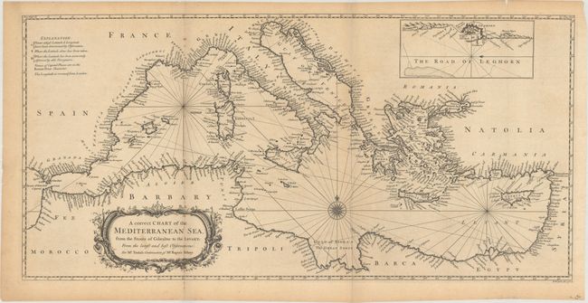
“A Correct Chart of the Mediterranean Sea, from the Straits of Gibraltar to the Levant; from the Latest and Best Observations”
Map Maker:
Richard William Seale
Finely engraved and detailed chart of the Mediterr... (full text available to subscribers)
| Item Detail |
| |
| |
MapMaker: |
Richard William Seale
|
|
| |
| |
Subject: |
Mediterranean |
|
| |
Period/Size: |
1751 / 13.5" x 27.7" (34.3 x 70.4 cm)
|
|
| |
Color: |
Black & White
|
|
| |
Condition: |
(B+) Issued folding with light toning, a few small stains, and a fold separation at bottom that extends 0.5" into the image. A few other minor separations and edge tears are all confined to the blank margins. (condition help) |
|
| |
Source: |
Tindal's Continuation of Rapin's Historyģ |
|
| |
References: |
Shirley (BL Atlases) G.RAP-2a #19. |
|
| |
|
|
| Sales Information |
| |
| |
Price: |
|
|
| |
| |
Offered by: |
Old World Auctions |
|
| |
Catalog: |
Auction No. 160 - Antique Maps, Charts, Atlases & Globes (9325) |
|
| |
Lot/Item #: |
623 |
|
| |
| |
Date: |
11/2016
|
|
| |
| |
|
Antique Maps - Valuation and Pricing, Descriptions, Resources |
|
Home |
Information |
Search |
Register |
Contact Us |
Site Map
Americana Exchange, Inc. © 1999 - 2024 Americana Exchange, Inc.. All rights reserved.
OldMaps.com, the OldMaps.com logo and
AMPR are service marks or registered service marks of Americana Exchange, Inc..
|