Title:
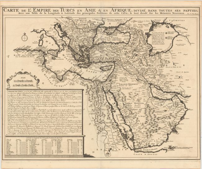
“Carte de l'Empire des Turcs en Asie & en Afrique, Divise dans Toutes ses Papties, avec une Table de la Longitude & Latitude des Principales Positions de Cette Carte...”
Map Maker:
Henry Abraham Chatelain
This detailed map illustrates the Ottoman Empire a... (full text available to subscribers)
| Item Detail |
| |
| |
MapMaker: |
Henry Abraham Chatelain
|
|
| |
| |
Subject: |
Eastern Mediterranean & Middle East, Arabia |
|
| |
Period/Size: |
1719 / 15.9" x 20.3" (40.4 x 51.6 cm)
|
|
| |
Color: |
Black & White
|
|
| |
Condition: |
(A) A dark impression on watermarked paper with a hint of offsetting and a centerfold separation at bottom that just enters the map border. Trimmed to the neatline at right near the bottom, as issued. (condition help) |
|
| |
Source: |
Atlas Historique… |
|
| |
References: |
Tibbetts #220. |
|
| |
|
|
| Sales Information |
| |
| |
Price: |
|
|
| |
| |
Offered by: |
Old World Auctions |
|
| |
Catalog: |
Auction No. 160 - Antique Maps, Charts, Atlases & Globes (9325) |
|
| |
Lot/Item #: |
644 |
|
| |
| |
Date: |
11/2016
|
|
| |
| |
|
Antique Maps - Valuation and Pricing, Descriptions, Resources |
|
Home |
Information |
Search |
Register |
Contact Us |
Site Map
Americana Exchange, Inc. © 1999 - 2024 Americana Exchange, Inc.. All rights reserved.
OldMaps.com, the OldMaps.com logo and
AMPR are service marks or registered service marks of Americana Exchange, Inc..
|