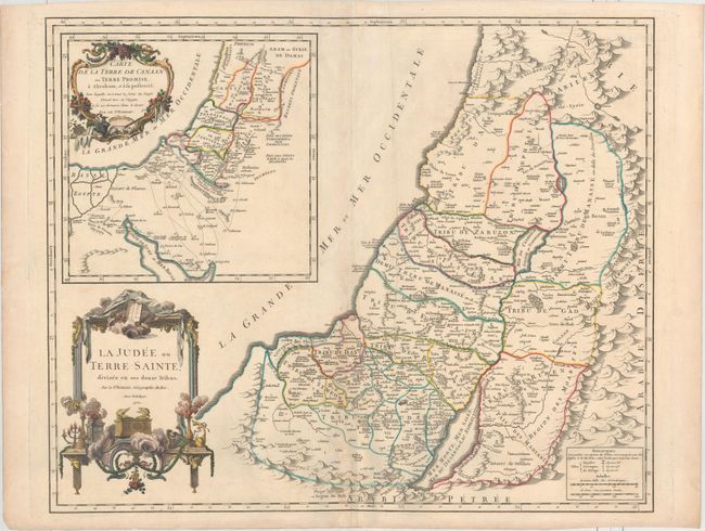
Title:
“La Judee ou Terre Sainte, Divisee en ses Douze Tribus”
Map Maker:
Gilles Robert de Vaugondy
Lovely, large map of the Holy Land divided among t... (full text available to subscribers)
| Item Detail |
| |
| |
MapMaker: |
Gilles Robert de Vaugondy
|
|
| |
| |
Subject: |
Holy Land |
|
| |
Period/Size: |
1750 / 18.9" x 23.2" (48.0 x 59.0 cm)
|
|
| |
Color: |
Colored
|
|
| |
Condition: |
(B+) A crisp impression on a watermarked sheet with some toning on the centerfold and a few creases. A repaired tear in the left margin is well away from the map. (condition help) |
|
| |
Source: |
Atlas Universel |
|
| |
References: |
Laor #667; Pedley #393. |
|
| |
|
|
| Sales Information |
| |
| |
Price: |
|
|
| |
| |
Offered by: |
Old World Auctions |
|
| |
Catalog: |
Auction No. 160 - Antique Maps, Charts, Atlases & Globes (9325) |
|
| |
Lot/Item #: |
664 |
|
| |
| |
Date: |
11/2016
|
|
| |
| |
|
Antique Maps - Valuation and Pricing, Descriptions, Resources |
|
Home |
Information |
Search |
Register |
Contact Us |
Site Map
Americana Exchange, Inc. © 1999 - 2024 Americana Exchange, Inc.. All rights reserved.
OldMaps.com, the OldMaps.com logo and
AMPR are service marks or registered service marks of Americana Exchange, Inc..
|