Title:
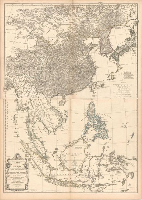
“Seconde Partie de la Carte d'Asie Contenant la Chine et Partie de la Tartarie, l'Inde au dela du Gange, les Isles Sumatra, Java, Borneo, Moluques, Philippines, et du Japon”
Map Maker:
Jean Baptiste Bourguignon d' Anville
This is a remarkably detailed map of eastern Asia,... (full text available to subscribers)
| Item Detail |
| |
| |
MapMaker: |
Jean Baptiste Bourguignon d' Anville
|
|
| |
| |
Subject: |
Eastern Asia |
|
| |
Period/Size: |
1752 / 19.3" x 27.2" (49.1 x 69.1 cm)
|
|
| |
Color: |
Colored
|
|
| |
Condition: |
(B+) Original outline color on watermarked paper with light toning along the centerfolds and edges of the sheets. On the northern sheet, there is an extraneous crease adjacent to centerfold at top and tiny tear in bottom blank margin that has been repair (condition help) |
|
| |
Source: |
|
|
| |
References: |
|
|
| |
|
|
| Sales Information |
| |
| |
Price: |
|
|
| |
| |
Offered by: |
Old World Auctions |
|
| |
Catalog: |
Auction No. 160 - Antique Maps, Charts, Atlases & Globes (9325) |
|
| |
Lot/Item #: |
694 |
|
| |
| |
Date: |
11/2016
|
|
| |
| |
|
Antique Maps - Valuation and Pricing, Descriptions, Resources |
|
Home |
Information |
Search |
Register |
Contact Us |
Site Map
Americana Exchange, Inc. © 1999 - 2024 Americana Exchange, Inc.. All rights reserved.
OldMaps.com, the OldMaps.com logo and
AMPR are service marks or registered service marks of Americana Exchange, Inc..
|