Title:
“Johnson's New Illustrated Family Atlas of the World, with Physical Geography, and with Descriptions Geographical, Statistical, and Historical...”
Map Maker:
Alvin Jewitt Johnson [& Co.]
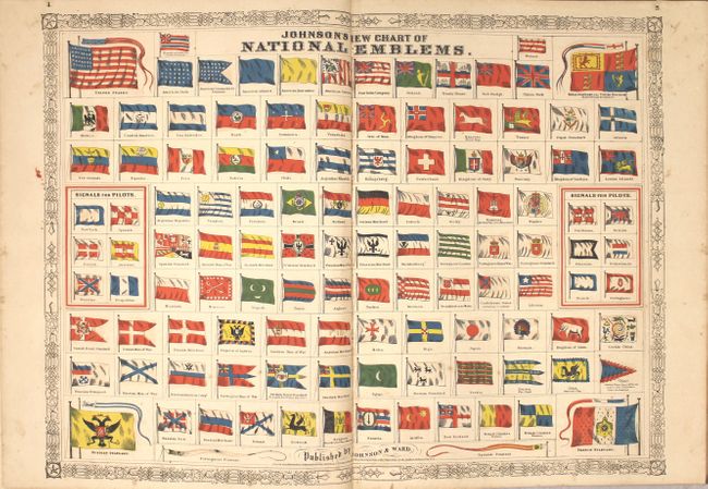
This complete folio atlas includes the beautiful <... (full text available to subscribers)
| Item Detail |
| |
| |
MapMaker: |
Alvin Jewitt Johnson [& Co.]
|
|
| |
| |
Subject: |
Atlases, World |
|
| |
Period/Size: |
1866 / 18.6" x 14.8" (47.3 x 37.6 cm)
|
|
| |
Color: |
Colored
|
|
| |
Condition: |
(B+) The maps are good to mostly very good with light scattered foxing and light toning. The United States map has a 4" fold separation at bottom (B), and the map of Massachusetts/Connecticut/Rhode Island is severed at lower left (C). Covers and spine h (condition help) |
|
| |
Source: |
|
|
| |
References: |
|
|
| |
|
|
| Sales Information |
| |
| |
Price: |
|
|
| |
| |
Offered by: |
Old World Auctions |
|
| |
Catalog: |
Auction No. 160 - Antique Maps, Charts, Atlases & Globes (9325) |
|
| |
Lot/Item #: |
805 |
|
| |
| |
Date: |
11/2016
|
|
| |
| |
|
Antique Maps - Valuation and Pricing, Descriptions, Resources |
|
Home |
Information |
Search |
Register |
Contact Us |
Site Map
Americana Exchange, Inc. © 1999 - 2024 Americana Exchange, Inc.. All rights reserved.
OldMaps.com, the OldMaps.com logo and
AMPR are service marks or registered service marks of Americana Exchange, Inc..
|