Title:
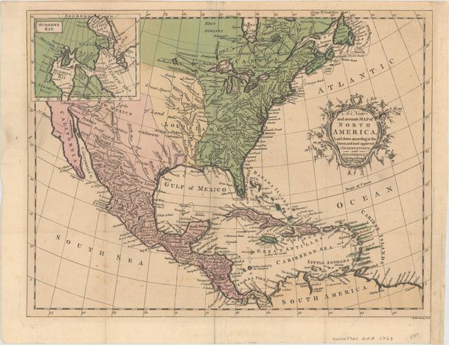
“A New and Accurate Map of North America, Laid Down According to the Latest, and Most Approved Observations, and Discoveries”
Map Maker:
John Hinton
This handsome map of colonial North America was pu... (full text available to subscribers)
| Item Detail |
| |
| |
MapMaker: |
John Hinton
|
|
| |
| |
Subject: |
Colonial North America |
|
| |
Period/Size: |
1763 / 10.3" x 13.4" (26.2 x 34.1 cm)
|
|
| |
Color: |
Colored
|
|
| |
Condition: |
(B+) Issued folding on watermarked paper with light scattered foxing. A binding trim at lower right has been repaired on verso with archival tape. Remnants of paper tape on verso. (condition help) |
|
| |
Source: |
Universal Magazine |
|
| |
References: |
Jolly #UNIV-110; Sellers & Van Ee #108. |
|
| |
|
|
| Sales Information |
| |
| |
Price: |
|
|
| |
| |
Offered by: |
Old World Auctions |
|
| |
Catalog: |
Auction No. 161 - Antique Maps, Charts, Atlases & Globes (9343) |
|
| |
Lot/Item #: |
100 |
|
| |
| |
Date: |
02/2017
|
|
| |
| |
|
Antique Maps - Valuation and Pricing, Descriptions, Resources |
|
Home |
Information |
Search |
Register |
Contact Us |
Site Map
Americana Exchange, Inc. © 1999 - 2024 Americana Exchange, Inc.. All rights reserved.
OldMaps.com, the OldMaps.com logo and
AMPR are service marks or registered service marks of Americana Exchange, Inc..
|