Title:
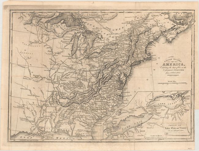
“United States of America, Exhibiting the Seat of War on the Canadian Frontier from 1812 to 1815”
Map Maker:
Edward Baines
An uncommon map of the early United States, publis... (full text available to subscribers)
| Item Detail |
| |
| |
MapMaker: |
Edward Baines
|
|
| |
| |
Subject: |
Eastern United States & Canada |
|
| |
Period/Size: |
1816 / 9.7" x 13.6" (24.7 x 34.6 cm)
|
|
| |
Color: |
Black & White
|
|
| |
Condition: |
(B+) Issued folding with a 1" binding tear at right and a 1.25" fold separation at bottom that have both been repaired on verso with archival tape. Faint offsetting. (condition help) |
|
| |
Source: |
|
|
| |
References: |
|
|
| |
|
|
| Sales Information |
| |
| |
Price: |
|
|
| |
| |
Offered by: |
Old World Auctions |
|
| |
Catalog: |
Auction No. 161 - Antique Maps, Charts, Atlases & Globes (9343) |
|
| |
Lot/Item #: |
140 |
|
| |
| |
Date: |
02/2017
|
|
| |
| |
|
Antique Maps - Valuation and Pricing, Descriptions, Resources |
|
Home |
Information |
Search |
Register |
Contact Us |
Site Map
Americana Exchange, Inc. © 1999 - 2024 Americana Exchange, Inc.. All rights reserved.
OldMaps.com, the OldMaps.com logo and
AMPR are service marks or registered service marks of Americana Exchange, Inc..
|