Title:
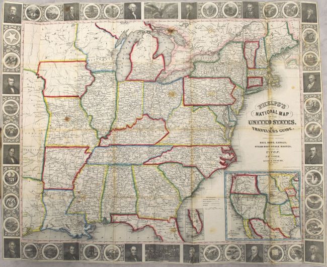
“Phelps's National Map of the United States, a Travellers Guide. Embracing the Principal Rail Roads, Canals, Steam Boat & Stage Routes, Throughout the Union”
Map Maker:
Phelps, Ensign & Thayer
This is the fourth edition folding pocket map that... (full text available to subscribers)
| Item Detail |
| |
| |
MapMaker: |
Phelps, Ensign & Thayer
|
|
| |
| |
Subject: |
Eastern United States |
|
| |
Period/Size: |
1850 / 20.4" x 25.8" (51.9 x 65.6 cm)
|
|
| |
Color: |
Colored
|
|
| |
Condition: |
(B) A bright example with light toning and foxing, small stains, and several short splits at fold intersections resulting in minor loss of image. Text is lightly foxed and detached from the covers. Covers are worn and spine is chipped at bottom. (condition help) |
|
| |
Source: |
|
|
| |
References: |
Howes #P291. |
|
| |
|
|
| Sales Information |
| |
| |
Price: |
|
|
| |
| |
Offered by: |
Old World Auctions |
|
| |
Catalog: |
Auction No. 161 - Antique Maps, Charts, Atlases & Globes (9343) |
|
| |
Lot/Item #: |
168 |
|
| |
| |
Date: |
02/2017
|
|
| |
| |
|
Antique Maps - Valuation and Pricing, Descriptions, Resources |
|
Home |
Information |
Search |
Register |
Contact Us |
Site Map
Americana Exchange, Inc. © 1999 - 2024 Americana Exchange, Inc.. All rights reserved.
OldMaps.com, the OldMaps.com logo and
AMPR are service marks or registered service marks of Americana Exchange, Inc..
|