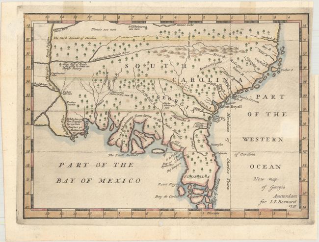
Title:
“New Map of Georgia”
Map Maker:
Jean Frederic Bernard
This is a scarce map that is one of the earliest p... (full text available to subscribers)
| Item Detail |
| |
| |
MapMaker: |
Jean Frederic Bernard
|
|
| |
| |
Subject: |
Colonial Southeast United States |
|
| |
Period/Size: |
1737 / 7.5" x 10.3" (19.1 x 26.2 cm)
|
|
| |
Color: |
Colored
|
|
| |
Condition: |
(B+) Very nice example with bright impression on hand laid paper with "Sprae" watermark. There are two areas of paper weakness that appear to have been made during paper manufacture. Expert repair to small hole in margin. There are light tape stains in (condition help) |
|
| |
Source: |
Recueil des Voyages... |
|
| |
References: |
Cumming (SE) #234. |
|
| |
|
|
| Sales Information |
| |
| |
Price: |
|
|
| |
| |
Offered by: |
Old World Auctions |
|
| |
Catalog: |
Auction No. 161 - Antique Maps, Charts, Atlases & Globes (9343) |
|
| |
Lot/Item #: |
201 |
|
| |
| |
Date: |
02/2017
|
|
| |
| |
|
Antique Maps - Valuation and Pricing, Descriptions, Resources |
|
Home |
Information |
Search |
Register |
Contact Us |
Site Map
Americana Exchange, Inc. © 1999 - 2024 Americana Exchange, Inc.. All rights reserved.
OldMaps.com, the OldMaps.com logo and
AMPR are service marks or registered service marks of Americana Exchange, Inc..
|