Title:
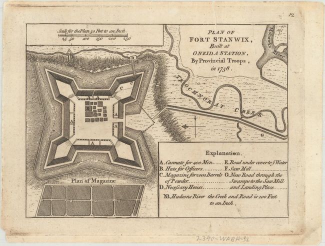
“Plan of Fort Stanwix, Built at Oneida Station, by Provincial Troops, in 1758”
Map Maker:
Mary Ann Rocque
This bird's-eye plan depicts the star-shaped Fort ... (full text available to subscribers)
| Item Detail |
| |
| |
MapMaker: |
Mary Ann Rocque
|
|
| |
| |
Subject: |
Fort Stanwix, New York |
|
| |
Period/Size: |
1765 / 4.8" x 6.4" (12.2 x 16.3 cm)
|
|
| |
Color: |
Black & White
|
|
| |
Condition: |
(B+) A nice impression on watermarked paper with an archivally repaired tear that enters image 1.25" at top (in title cartouche), a few tiny tears in top blank margins, and light marginal soiling. Remnants of hinge tape on verso. (condition help) |
|
| |
Source: |
A Set of Plans and Forts in America... |
|
| |
References: |
Phillips (Atlases) #1186-26; Sellers & Van Ee #1133; Shirley (BL Atlases) T.ROCQ-2a #12. |
|
| |
|
|
| Sales Information |
| |
| |
Price: |
|
|
| |
| |
Offered by: |
Old World Auctions |
|
| |
Catalog: |
Auction No. 161 - Antique Maps, Charts, Atlases & Globes (9343) |
|
| |
Lot/Item #: |
337 |
|
| |
| |
Date: |
02/2017
|
|
| |
| |
|
Antique Maps - Valuation and Pricing, Descriptions, Resources |
|
Home |
Information |
Search |
Register |
Contact Us |
Site Map
Americana Exchange, Inc. © 1999 - 2024 Americana Exchange, Inc.. All rights reserved.
OldMaps.com, the OldMaps.com logo and
AMPR are service marks or registered service marks of Americana Exchange, Inc..
|