Title:
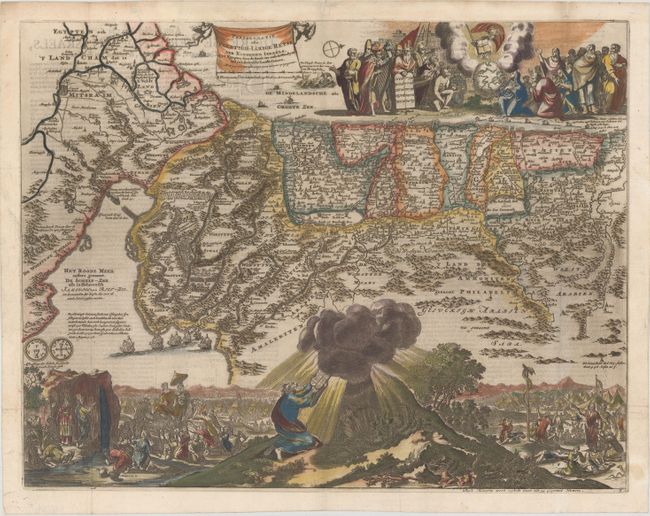
“Perigrinatie ofte Veertigh-Iarige Reyse der Kinderen Israels uyt Egypten, door de Roode-Zee, ende de Woestyne tot in't Beloofde Landt Canaan…”
Map Maker:
Jan van den Avelen
This splendid Dutch Bible map of the Holy Land ill... (full text available to subscribers)
| Item Detail |
| |
| |
MapMaker: |
Jan van den Avelen
|
|
| |
| |
Subject: |
Holy Land |
|
| |
Period/Size: |
1687 / 14.0" x 18.1" (35.6 x 46.0 cm)
|
|
| |
Color: |
Colored
|
|
| |
Condition: |
(A) Issued folding on paper with a sun watermark, some printer's ink residue, and minor marginal soiling. (condition help) |
|
| |
Source: |
|
|
| |
References: |
Poortman & Augusteijn #150. |
|
| |
|
|
| Sales Information |
| |
| |
Price: |
|
|
| |
| |
Offered by: |
Old World Auctions |
|
| |
Catalog: |
Auction No. 161 - Antique Maps, Charts, Atlases & Globes (9343) |
|
| |
Lot/Item #: |
656 |
|
| |
| |
Date: |
02/2017
|
|
| |
| |
|
Antique Maps - Valuation and Pricing, Descriptions, Resources |
|
Home |
Information |
Search |
Register |
Contact Us |
Site Map
Americana Exchange, Inc. © 1999 - 2024 Americana Exchange, Inc.. All rights reserved.
OldMaps.com, the OldMaps.com logo and
AMPR are service marks or registered service marks of Americana Exchange, Inc..
|