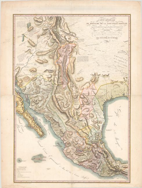
Title:
“Carte Generale du Royaume de la Nouvelle Espagne...”
Map Maker:
Alexander von Humboldt
This is the first French edition of Humboldt's lan... (full text available to subscribers)
| Item Detail |
| |
| |
MapMaker: |
Alexander von Humboldt
|
|
| |
| |
Subject: |
Southwestern United States & Mexico |
|
| |
Period/Size: |
1811 / 38.8" x 26.9" (98.6 x 68.4 cm)
|
|
| |
Color: |
Colored
|
|
| |
Condition: |
(A) A crisp impression with minor soiling mostly in the blank margins and short fold separations at center and in the top and bottom blank margin that have all been archivally repaired on verso. Two small damp stains and several tiny edge tears are all c (condition help) |
|
| |
Source: |
Atlas Geographique et Physique du Royaume de la Nouvelle-Espagne |
|
| |
References: |
Wheat (TMW) #272; Cohen pp. 100-101; Sabin #33756; Streeter #1042; Howes #H786. |
|
| |
|
|
| Sales Information |
| |
| |
Price: |
|
|
| |
| |
Offered by: |
Old World Auctions |
|
| |
Catalog: |
Auction No. 161 - Antique Maps, Charts, Atlases & Globes (9343) |
|
| |
Lot/Item #: |
389 |
|
| |
| |
Date: |
02/2017
|
|
| |
| |
|
Antique Maps - Valuation and Pricing, Descriptions, Resources |
|
Home |
Information |
Search |
Register |
Contact Us |
Site Map
Americana Exchange, Inc. © 1999 - 2024 Americana Exchange, Inc.. All rights reserved.
OldMaps.com, the OldMaps.com logo and
AMPR are service marks or registered service marks of Americana Exchange, Inc..
|