Title:
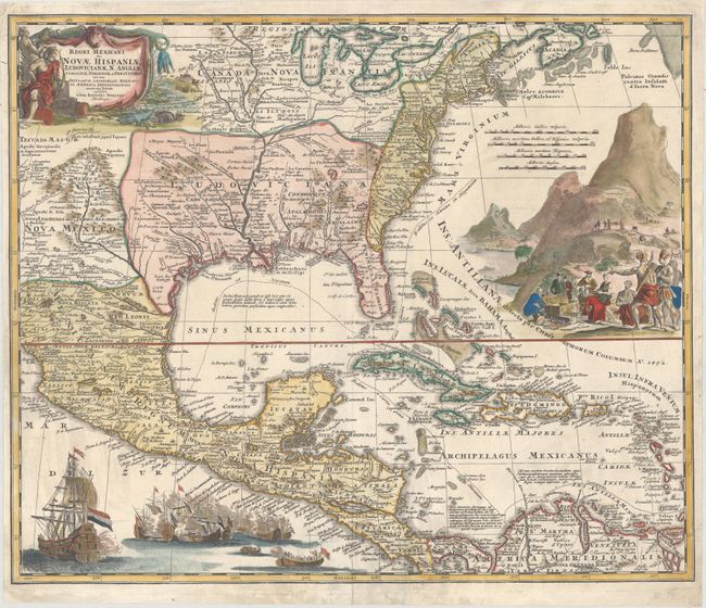
“Regni Mexicani seu Novae Hispaniae, Ludovicianae, N. Angliae, Carolinae, Virginiae et Pensylvaniae, nec non Insularum Archipelagi Mexicani in America Septentrionali Accurata Tabula…”
Map Maker:
Johann Baptist Homann
This superb map covers the region from the Great L... (full text available to subscribers)
| Item Detail |
| |
| |
MapMaker: |
Johann Baptist Homann
|
|
| |
| |
Subject: |
Colonial Eastern North America & West Indies |
|
| |
Period/Size: |
1720 / 18.8" x 22.4" (47.8 x 56.9 cm)
|
|
| |
Color: |
Colored
|
|
| |
Condition: |
(B+) A bright example on watermarked paper with original color in the map and later color in the decorative elements. There are professional repairs to separations along the centerfold, a tear that extends 1.5" into Costa Rica at bottom, and a small hole (condition help) |
|
| |
Source: |
|
|
| |
References: |
Van Ermen, p.42; Manasek #72; Martin & Martin #17; Portinaro & Knirsch #CXV. |
|
| |
|
|
| Sales Information |
| |
| |
Price: |
|
|
| |
| |
Offered by: |
Old World Auctions |
|
| |
Catalog: |
Auction No. 162 - Antique Maps, Charts, Atlases & Globes (9354) |
|
| |
Lot/Item #: |
100 |
|
| |
| |
Date: |
04/2017
|
|
| |
| |
|
Antique Maps - Valuation and Pricing, Descriptions, Resources |
|
Home |
Information |
Search |
Register |
Contact Us |
Site Map
Americana Exchange, Inc. © 1999 - 2024 Americana Exchange, Inc.. All rights reserved.
OldMaps.com, the OldMaps.com logo and
AMPR are service marks or registered service marks of Americana Exchange, Inc..
|