Title:
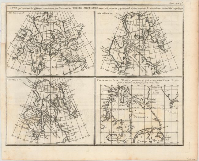
“Carte qui Represente les Differentes Connoissances que l'on a eues des Terres Arctiques Depuis 1650 Jusqu'en 1747...”
Map Maker:
Didier Robert de Vaugondy
This is the second state of a fascinating group of... (full text available to subscribers)
| Item Detail |
| |
| |
MapMaker: |
Didier Robert de Vaugondy
|
|
| |
| |
Subject: |
Eastern Canada |
|
| |
Period/Size: |
1773 / 12.0" x 15.1" (30.5 x 38.4 cm)
|
|
| |
Color: |
Black & White
|
|
| |
Condition: |
(B+) Issued folding on watermarked paper with faint offsetting and minor foxing. A binding trim at top left has been replaced with paper. (condition help) |
|
| |
Source: |
Diderot's Encyclopedie (Supplement) |
|
| |
References: |
Kershaw #477; Pedley #24. |
|
| |
|
|
| Sales Information |
| |
| |
Price: |
|
|
| |
| |
Offered by: |
Old World Auctions |
|
| |
Catalog: |
Auction No. 162 - Antique Maps, Charts, Atlases & Globes (9354) |
|
| |
Lot/Item #: |
107 |
|
| |
| |
Date: |
04/2017
|
|
| |
| |
|
Antique Maps - Valuation and Pricing, Descriptions, Resources |
|
Home |
Information |
Search |
Register |
Contact Us |
Site Map
Americana Exchange, Inc. © 1999 - 2024 Americana Exchange, Inc.. All rights reserved.
OldMaps.com, the OldMaps.com logo and
AMPR are service marks or registered service marks of Americana Exchange, Inc..
|